Transformation Story
But it wasn’t always so. In 1960, Governor Edmund G. “Pat” Brown’s administration decided California’s capital should emulate the monumental seat of government located in Albany, New York. In the 1960’s , the State purchased 90 percent of the land south of L Street adjacent to the Capitol and commenced demolition of the neighborhood to construct a high-rise office complex within a park-like setting mirroring Capitol Park. This monumental plan envisioned office buildings set in open paved plaza.
Four new state office buildings were built, but due to lack of funding and a change in administration, work on the plan ceased. In the ten years following the state’s large-scale property acquisition and building demolition program, the population of the once thriving neighborhood diminished from 4,000 to less than 1,000. By the mid-seventies, the 40 block area south of the State Capitol Building was characterized by detox centers, boarded-up buildings, crime, and a sea of surface parking lots.
In 1975, the new administration of Governor Edmund G. Brown Jr., ordered an update of the Capitol Area Plan to address the State’s need for office space. The governor lived on the top floor of the Dean Apartments at 1400 N Street, one of the distinguished buildings on Capitol Park originally slated for demolition by the 1960s State Capitol Plan. Like his father, Jerry Brown wanted a place the people of California could be proud of, but he felt a government seat should be ‘approachable’ rather than ‘monumental’ and that this could be achieved by mixing housing with state offices rather than building a single-purpose office zone.
In 1978, CADA was created to build the residential and neighborhood commercial components of Jerry Brown’s Capitol Area Plan. Its offices were established in the very neighborhood it was charged to care for. The revised plan addressed conservation, mixed-use, and pleasant human environments.
“The State Capitol shall be the focal point of any Capitol Area Plan; buildings, fountains, pedestrian areas, and landscaping surrounding this center of State government shall complement and beautify this building… There should be a variety of open spaces all designed to a human scale – tight, intimate spaces- open vistas- places for active movement as well as contemplative retreats. These should all be placed on a network of shady routes which people travel from one place to another.” – The 1977 Capitol Area Plan.
With CADA’s involvement, things started to change. CADA rehabbed 11 buildings in the vicinity of 14th and O; established a rent-assistance program; built a senior-citizens complex; demolished buildings too far gone to save; and initiated rebuilding projects on blocks where buildings could be salvaged. Neighborhood institutions Luna’s Café & Juice Bar and Simon’s Bar & Café opened around this time, and the rest of the decade saw continuing transformation, culminating in construction of the State East End Project.
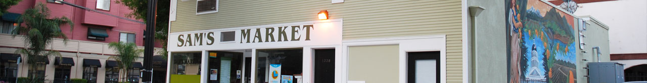
Through the decades, one neighborhood landmark has survived and thrived. Sam’s Market at 1330 O Street arrived on the scene in 1957 and has played a vital role in the neighborhood ever since. For more than 50 years, the corner store housed in an early 20th-century building has served Capitol Park residents, government officials and workers, winning loyalty and affection with its friendly spirit and quaint charm. On Earth Day 2008, the community celebrated CADA’s the rehabilitation of this three-story structure, which included restoration of early 20th-century architectural features were restored and the addition of an exterior mural by Sacramento Michael Mikolon.